


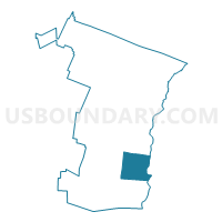
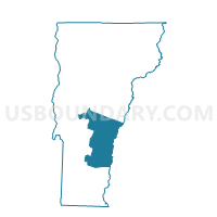
Weathersfield Voting District, Windsor County, Vermont
About
Outline

Summary
| Unique Area Identifier | 680963 |
| Name | Weathersfield Voting District |
| County | Windsor County |
| State | Vermont |
| Area (square miles) | 44.20 |
| Land Area (square miles) | 43.64 |
| Water Area (square miles) | 0.56 |
| % of Land Area | 98.73 |
| % of Water Area | 1.27 |
| Latitude of the Internal Point | 43.39210770 |
| Longtitude of the Internal Point | -72.47678250 |
Maps

Graphs
Select a template below for downloading or customizing gragh for Weathersfield Voting District, Windsor County, Vermont


Neighbors
Neighoring Voting District (by Name) Neighboring Voting District on the Map
- Baltimore Voting District, Windsor County, VT
- Cavendish Voting District, Windsor County, VT
- Chester Voting District, Windsor County, VT
- CLAREMONT WARD 2, Sullivan County, NH
- CLAREMONT WARD 3, Sullivan County, NH
- Reading Voting District, Windsor County, VT
- Springfield District 2, Windsor County, VT
- TOWN OF CORNISH Voting District, Sullivan County, NH
- West Windsor Voting District, Windsor County, VT
- Windsor Voting District, Windsor County, VT
Top 10 Neighboring County Subdivision (by Population) Neighboring County Subdivision on the Map
- Claremont city, Sullivan County, NH (13,355)
- Springfield town, Windsor County, VT (9,373)
- Windsor town, Windsor County, VT (3,553)
- Chester town, Windsor County, VT (3,154)
- Weathersfield town, Windsor County, VT (2,825)
- Cornish town, Sullivan County, NH (1,640)
- Cavendish town, Windsor County, VT (1,367)
- West Windsor town, Windsor County, VT (1,099)
- Reading town, Windsor County, VT (666)
- Baltimore town, Windsor County, VT (244)
Top 10 Neighboring Place (by Population) Neighboring Place on the Map
Top 10 Neighboring Elementary School District (by Population) Neighboring Elementary School District on the Map
- Chester-Andover Union School District 29, VT (3,621)
- Cornish School District, NH (1,640)
- Cavendish School District, VT (1,367)
- West Windsor School District, VT (1,099)
- Reading School District, VT (666)
Top 10 Neighboring Secondary School District (by Population) Neighboring Secondary School District on the Map
- Woodstock Union High School District 4, VT (7,312)
- Green Mountain Union High School District 35, VT (4,988)
Top 10 Neighboring Unified School District (by Population) Neighboring Unified School District on the Map
- Claremont School District, NH (13,355)
- Springfield School District, VT (9,373)
- Windsor School District, VT (3,553)
- Weathersfield School District, VT (2,825)
- Baltimore School District, VT (244)
Top 10 Neighboring State Legislative District Lower Chamber (by Population) Neighboring State Legislative District Lower Chamber on the Map
- State House District 4, Sullivan County, NH (16,180)
- Windsor-1-2 State House District, VT (9,247)
- State House District 1, Sullivan County, NH (6,989)
- Windsor-4 State House District, VT (4,492)
- Windsor-2 State House District, VT (4,192)
- Windsor-1-1 State House District, VT (3,991)
- Windsor-5 State House District, VT (3,714)
- Windsor-3 State House District, VT (3,553)
Top 10 Neighboring State Legislative District Upper Chamber (by Population) Neighboring State Legislative District Upper Chamber on the Map
- Windsor State Senate District, VT (56,670)
- State Senate District 8, NH (54,222)
- State Senate District 5, NH (53,856)
Top 10 Neighboring 111th Congressional District (by Population) Neighboring 111th Congressional District on the Map
Top 10 Neighboring Census Tract (by Population) Neighboring Census Tract on the Map
- Census Tract 9758, Sullivan County, NH (4,712)
- Census Tract 9759.01, Sullivan County, NH (4,695)
- Census Tract 9667, Windsor County, VT (4,298)
- Census Tract 9665, Windsor County, VT (4,187)
- Census Tract 9751, Sullivan County, NH (4,004)
- Census Tract 9660, Windsor County, VT (3,553)
- Census Tract 9659, Windsor County, VT (3,320)
- Census Tract 9661, Windsor County, VT (2,825)
- Census Tract 9662, Windsor County, VT (1,611)
Top 10 Neighboring 5-Digit ZIP Code Tabulation Area (by Population) Neighboring 5-Digit ZIP Code Tabulation Area on the Map
- 03743, NH (14,103)
- 05156, VT (9,226)
- 05089, VT (4,979)
- 05143, VT (4,343)
- 05151, VT (1,553)
- 03745, NH (1,424)
- 05150, VT (831)
- 05062, VT (702)
- 05142, VT (680)
- 05037, VT (560)